Sunday, August 22, 1999

Kahana Rescue!

HTMC and OHE-L members Thomas Yoza, Ken Suzuki, Jim Pushaw, and Naomi Nasu will be in the spotlight for their efforts today in Kahana Valley. Motivated by Ken's hunch, the group broke off from the main body of the HTMC trail maintenance crew to see if they could find any sign of the two Danish females, Anitta Winther & Marianne Konnerup, reportedly last seen in Kahana on Sat. 8/14.
HTMC and OHE member Joe Bussen, along with his wife Ruby, was hiking in Kahana on 8/14, and they recalled seeing the two girls hiking up the road to the water tank around 12:30. Given that, along with reports from a city bus driver and some Kahana residents, there was plenty of evidence the two were somewhere in Kahana. But where?
This past week, police, fire, and civilian personnel attempted rescue searches in Kahana and nearby windward locales without success. As we worked in the valley today, rescue choppers buzzed overhead while a small crew of police special forces officers searched valley trails on foot. Reports indicated the girls were inexperienced hikers, so the natural assumption was that they'd likely stick to the muddy but non-treacherous trails in the valley instead of attempting ridge routes to the south (Ohulehule) or north (Pauao). As we'd find out, this assumption proved faulty.
While we did our work, we kept an eye out for any signs of the girls. Early on, Mabel reported smelling a foul odor on the Na Koa Trail (the extension opened up by Dick Davis). However, this turned out to be a false lead.
At noon, most of us continued clearing and searching in the upper part of the valley. Meanwhile, Ken, Jim, Thomas, and Naomi headed makai to pick up the trail leading over to Ohulehule. When they reached the dirt road leading down to the dam, a crowd of reporters, police, fire and state officials, and family members of the girls were assembled for a press conference. Based on the circumstances and the to-date search efforts, today would likely be the final effort by rescue personnel to look for the girls. If they weren't found today, they probably would never be, at least not alive.
Around 1:30, the Ken, Thomas, Jim, and Naomi began the ascent of the spur leading up to Ohulehule. For those who haven't done this, the climb is steep and strenuous, with fixed ropes in a couple places. While going up, they decided to set a turnaround time of 2 p.m., taking into account their energy level and the time needed to hike back to the cars.
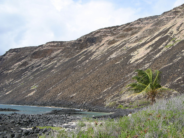
While climbing to a saddle in the ridge (elev. 1,560), Jim whooped out and heard a faint reply of a female voice upridge, something like, "We're here. Can you see us?" Subsequent whoops netted a reply like, "Please help us!"
Infused with adrenaline after hearing the cries for help, Thomas, Jim, and Ken powered up the spur to the girls (Naomi was further down the spur). When the girls came into view, they were slowly descending the lowest cable section on the steep face of Ohulehule, encouraged and coached by Thomas, Jim, and Ken. The girls later revealed that they had decided to deal with their fears and attempt a descent today, for they felt they wouldn't last much longer if they didn't.
Somewhere in all of this, Thomas radioed Mabel Kekina (trail maintenance boss) via walkie talkie that they'd found the girls. Meanwhile, Jim tried hailing 911 on his cell phone without success. Ken, at or about this time, was able to get through on his cell phone to 911 (the 911 operator at first was skeptical about the veracity of the call and took Ken's cell # and called him back for confirmation). Convinced that Ken was on the up-and-up, the operator dispatched a chopper to the valley.
While the girls waited for the chopper, they talked about their ordeal. They climbed Ohulehule (summit 2,265) without incident but when it came time to head down they were too afraid to attempt it. I'm not clear if their intent was to climb Ohulehule or if a wrong turn from a valley trail led them to the mountain.
The girl's trepidation about descending is understandable since they were confronted with the severe steepness of the mountainside while going down (when heading up, all they needed to focus on was the slope dead ahead). Displaying some rational thinking, the girls thought it would be better to stay put on the summit instead of descending and risking getting hurt or worse.
A fire official on tonight's news said the girls had fallen off the ridge and were trapped in an inaccessible spot. However, this is not what the girls reported to Ken and company. Instead, the twosome opted to remain at the summit, hoping a passing chopper would see them waving their jackets. The girls said they saw choppers on numerous occasions but not once did one do a fly-by over the crest of Ohulehule. Instead, air search efforts were concentrated on the valley.
For food, the girls set off on Saturday with a bagel, an apple and some chewing gum. I'm not sure how much water they began with (a liter apiece?) but when their packed supply was gone (most likely by the first night), they had to resort to sucking water off moss and leaves or, when a rainshower passed, opening their mouths to capture any water that fell in. And once the bagel and apple was gone, the girls relied on thimble berries and the berries from clidemia for sustenance.
Fortunately, Ken, the master of preparation, makes a point of carrying a can of soda or two and snack items (usually cookies) in his pack, and the girls were thankful for this, along with water offered by Jim, Thomas, and Ken.
The rescue chopper arrived around 2:30, guided by Ken via cell phone to the saddle lunchspot (formerly used by the HTMC on club hikes). A first then a second fireman rappeled from the chopper to the lunchspot clearing. The chopper then left, returning some minutes later with a rescue basket attached. Accompanied by one of the two firemen, one girl was whisked away in the basket to a clearing by the watertank where she was moved from the basket into the chopper for the ride down the valley to a clearing by the Kahana visitor's center where a crowd of officials, reporters, family members, and passers-by were assembled. Repeat the process for the second girl.
Tried-and-true hikers, Thomas, Jim, Ken, and Naomi opted against a chopper ride out and hiked down the mountain, across the valley, and back to the parking area by the hunter's check-in.
When the rescue foursome arrived, a cheer rang out from members of our proud HTMC crew, waiting with drinks and snacks. Mabel gave each a big hug while reporters from KHNL (News 8) and the Honolulu Advertiser snapped pictures/shot video (this will be the big local news story for the next few days, for sure).
I just spoke to Jim Pushaw a few minutes ago on the phone, and he told me reporters from the local TV stations have been ringing his house all evening. As a matter of fact, one reporter from News 8 asked him to lead a camera crew up the mountain tomorrow morning so they can shoot footage of the location of the rescue and the summit where the girls spent the past eight nights. I'm not sure if Jim will decide to lead them but I offered him some feedback on things to consider.
Hopefully, the publicity the rescue generates won't lead crazies or the ill-prepared to make an ascent of the mountain.
I'm sure Anitta and Marianne learned much from this. Ditto for police and fire officials, who probably have an increased respect for the ableness and mountain savvy of members of the Hawaiian Trail and Mountain Club.
Hike safe,
--DKT

Reply From: peter caldwell (pekelo@lava.net> Great news.! Let's hear it for our four heroes and their intuition! I was coming back from a long paddling day and was listening to KCCN-FM when the wahine DJ said the girls have been found. Knowing the Kahana trail clearing was the plan for the day, I had this feeling so when I got home and fired up the computer, sure enough!!! Anybody gets lost again, first thing on the agenda should be a consultation with HTM! Dr. Pete

Reply From: Carmen C. (carmenc@pixi.com> Due to travel, I had heard nothing about this terrible situation until this morning from the HTM members who are currently preparing to kayak from Ha'ena to Polihale tomorrow morning. The grimness of the situation was discussed for a bit and then the preparation activities of the morning took over. I later asked what trail was being cleared today and when I heard it was Kahana, like Pete, had a really good feeling that there was nothing to worry about. On my way from the airport back to Kailua at around 5:00 I heard that the girls had been found but heard no details. As I got home, my grandmother came running out of the house yelling to the neighborhood that my trail clearing friends were the heroes. Jay's e-mail confirmed this and I wouldn't be surprised if my neighbors get onto OHE after this. Jim, Tom, Ken, and Naomi...you did good. Carmen :-)

Reply from: Thomas Yoza (tyoza@gte.net> Dayle and I were the last to leave Kahana Valley today and as we were driving out a KITV4 News car stopped and was talking to Dayle. Then I could see him pointing back at me and the reporter, Jill Kuramoto, came running up to me and asked if I could do an interview. At this point Dayle took off and I got stuck doing a solo spot for KITV. I watched it at 10 and then looked at the KHNL report.... both were pretty good. Also got a call from the Honolulu Starbulletin who said they had just talked to Ken... so look at their web site tomorrow.
I asked Annita why they climbed up Ohulehule and she said they started on a "family" hiking trail and made a wrong turn, probably just past the dam, and continued following the flags left over from the previous HTMC hike. Personally I find that hard to believe, especially when they hit the rope sections. As we climbed up the ridge, Ken noted that no tracks could be seen on the trail so we might as well turn back. I yelled back that 2:00pm and the Waikane Saddle lunch spot should be our goal. The rest is history!
Aloha, Thomas

Reply From: "STONE, J. BRANDON" (802005%cchpd@co.honolulu.hi.us> First, congratulations to Ken, Jim, Thomas, and Naomi for playing a hunch that turned out to be a winner. Great job!
I'm the Management Analyst for the Chief of Police, so I'm trying to push the various forces involved in the right direction. I'm doing a lot of educating, for instance. I came in this morning, pulled out about a dozen photos of Pu'u Ohulehule, people on the summit of Ohulehule during our last trailclearing there, and the views from the top of Ohulehule. I also found a photo that included Ken and Thomas from our recent KST trip (sorry, Jim and Naomi; I had no photos of you). I put the photos into plastic sleeves and stuck them on the outside of my office door. Just about everyone on the floor (and many others) have stopped and checked them out. As a result, most of our adminstrators are now better informed about HTMC, Pu'u Ohulehule, some specifics of the incident, the dangers (and the pleasures) of hiking, etc.
One of our deputies had spoken to Mabel in the field on Friday (I think that was the day), but I'm not sure how much ongoing consultation there was with HTMC. As a result of this incident and its outcome, I would expect to see a tighter link during future rescues.
The media are still buzzing, of course. One TV station wants to see if the Danish women would do a public service announcement regarding safe hiking. Whether they do or not, we suggested that the station talk to HTMC in order to plan such a PSA. I gave them Grant and Mabel's phone numbers. Another station is checking with Chris Walker to see if he has any archival footage of the Ohulehule hike.
There's one thing I would like to clarify: Where did the women actually spend the eight days? Apparently, they didn't quite make it to the summit. Does anyone really know where they stayed?
I'll volunteer to pass any feedback from you folks to our administrators. That feedback could be formal (say, someone speaking for the club) or informal (just email me directly or call me at 529-3644). I can help set up communications links, too, if that is needed. This is a big organization and it's not always clear who to talk to about an issue.
Finally, what a marvellous outcome to a stressful incident!
Brandon

Reply From: malama@lava.netRight on, rescue team! *Cheers* for the gang from HTMC!!!
I wondered all week long why police, fire and DLNR officials did not approach the club for help -- you'd think some of them must be monitoring the OHE postings, what with all the attention on stuff like Haiku.
Congratulations to you all. Maika'i!
-- Mahealani

Reply from: Gabriela Canalizo (canaguby@palila.ifa.hawaii.edu>Sorry for the late message... I'm out of town and I was really excited to read the news on the paper.
Congrats and big mahalos to Ken, Thomas, Jim, and Naomi!! Great job, guys!
Gaby

Reply from: Dayle K. Turner (turner@hawaii.edu>The info from media reports seems to indicate they didn't reach the summit. After all, one of the girls said they had little/no room to lie down during the ordeal yet there is plenty of room at the top for that. My guess is that they were stranded at/around the steepest section, where there are multiple ropes/wires/cables. At that locale, the vegetation forms a canopy overhead, making seeing or being seen difficult.
Ken or Thomas told me the girls, before they began their descent, had untied a section of rope and cable in case they needed it further down.
I thought it was interesting that someone (Aaron Lowe?) in this morning's paper commented that survival for the duo was more likely since there were two of them and they were females. Females are more rational, said the quotee, and a pair of females tend to form a supportive team. A single young male, on the other hand, would have likely found his way down or killed himself in the attempt. Not real sure what this far-from-young male would have done.
And as for the theory that the women had Ohulehule as their goal from the get-go, their statements contradict this. Or maybe they're not telling the truth to avoid censure.
Regarding questions about why they kept climbing even after it became clear the route they were on was taking them far from the start point, I suppose their actions could be attributed to youthful vigor and a go-for-it attitude. Or maybe, as Ken said, they were disoriented and believed the trail would lead them out.
"We kept following the red line (ribbons?)," said one of the girls. Maybe the hunters taking down ribbons isn't such a bad thing.
In all, a great story with a happy ending.
Kudos to the nth degree to the heroes of Kahana--Ken, Jim, Thomas, and Naomi.
HTMC stands proud.
--DKT

Reply from: Sergio Lotenschtein (loetch@iav.com>Congratulations. It must feel wonderful to be recognized as the experienced hikers you all are. I do hope that the media and the state do not decide to knee-jerk and close off the area. Or that some fool legislator tries to restrict and control the access to these trails.
Thank you HTMC.
Sergio

Reply from: Joseph Omer Bussen (bussen@hawaii.edu>Kay Lynch asks if the girls maybe chose to go up a dry trail instead of the Kahana loop. Remember, Ruby and I saw them approaching the water tank at about 12:45 Saturday. I think they went around the loop, and took a wrong turn just before they would have reached the dam. Or, they reached the dam and wanted to do some more hiking, so they went back to the Ohulehule trail. The onlymystery to me is that they never figured out that the upper ridges are not a "family trail".
In any case, I don't think the proposal to put warning signs at the beginning of all "dangerous" traiils is the way to go. Better to more and better signs along established novice trails. Kahana Valley and the Nakoa Trail are (or should be) a perfect example of this. The one sign at the big X junction (by the tank traps and bunkers) is very confusing; I would expect any novice first-timer to turn the wrong way. Where the Ohulehule trail branches off to the left (after crossing the dam), why not just a double arrow on the right side of the trail, to show it extending inboth directions.
I hope some experienced HTMers will be on my hike Sunday, to take the lead. I don't hike fast enough to go in front, and I am afraid a very large number of hikers may show up. We are going to do the figure-8 double loop, exactly as in Stuart's book.
Slow Joe Bussen

Reply From: James R Pushaw (jrpushaw@juno.com>Thanks, first of all, to all of you for the kind comments directed to the four of us that were able to experience a once in a lifetime event. I can tell you that I am emotionally drained from this one, but love it at the same time. (?) The story has been told at length, but I want to share some of my observations with you.
I will never forget the shock, the rush of emotions that seemed to go through every fiber of my body when the girls answered us back. It is very hard to put all of this into words but what an absolute thrill it was. Even though Mabel Kekina had briefed us earlier in the morning about the sad possibility of finding only their bodies, we had been letting out our usual "whoops" every 20 minutes or so, with some hope that the girls were still able to hear us. Sadly, it seems that we were getting used to hearing nothing but silence. But then, after what became the last whoop that we actually needed, we heard not just a faint whisper, but shouting - loud shouting - as if they both had megaphones! They must have gathered up all the energy that they had when they yelled back! In fact, I don't even remember all that they said, the thrill was so great, but I did hear the word HELP! somewhere in there.
We knew that it HAD to be them. They really are here! They really are OK! A moment of hesitation as we thought that it could be someone else, but that was quickly dismissed. I yelled "Can you see us?" and waved my hands. Their answer "No, can you see US?" We couldn't. From where the sound came from, they were quite a bit higher than us and in looking, all we could see is green, green, green - just the foliage. I yelled to them to hang in there, that we were coming. Thinking that they may be somewhere down the side of the ridge facing the ocean, I asked Thomas if he had any rope with him. He said yes, but we never needed it. It took us another 20 minutes or so to get up to the old "lunch spot" which could now be more accurately called the "helicopter rescue spot." It was some relief to reach that spot, as it is nearly level there compared to the strenuous ridge climb that we just finished. We were moving faster toward them, but before we even got to them, we hear "Do you have any water?"
Then, just a little bit further and we could finally see them! I will never forget the sight - both of them were stopped in their tracks, Anitta in front and Marianne above and behind her, looking like she was down on one knee, sort of sliding down a slight hill. Anitta's eyes were piercing, looking with almost disbelief, it seemed, and at the same time happy, sad, stunned and I guess mostly relieved. I asked if they were OK, or if they had any broken bones. They said no, that they were all right. I reached Anitta first, and not surprisingly, the first thing she asked for was water. Handing her the tube from my camelbak, she was trying her best but couldn't get any water flowing. I got it started and she just loved it. Next was Marianne. We all then started back to the lunch spot to have a little more room and to get away from the tree cover. When we got there,(sure enough, Dayle) Ken had Cokes and some chocolate chip cookies. They ate and drank lightly, also sharing a peach that I had forgotten from my lunch, and more water. Only after the brief snack and some talking did they finally seem to be more relaxed, showing us that they finally must have felt that things were going to work out for them, that all would be OK. Their legs were heavily scratched and bruised, as they were wearing shorts and their arms and hands were very dirty with some cable or rope cuts on their palms. But considering what they went through, they looked pretty good.
Thomas had kept in constant touch with Mabel with the small radios that each had since we first heard the girls. When he first told Mabel that we had found the girls, we thought that Mabel was out by the police and firemen, so we figured that she could just walk over and tell them. In later discussions we realized that she was still somewhere back in the valley. So I tried calling 911 on my phone, but had no signal. Ken then got busy with his cell phone because his worked! ( I am going to call Honolulu Cellular to find out why mine didn't work and Ken's did. Which service do you have Ken?) About this time Thomas started heading down to go and tell Naomi what was going on. She had stopped to rest and wait for us to come back, probably thinking that we wouldn't be too long. Now that there was all the commotion of the helicopters, Thomas was concerned that Naomi would be worrying about what was going on. (When we met up with her again, we found that she WAS worried and actually had come half way up to us until she met Thomas coming down.)
The 911 operator must have thought it was a prank call, because after asking for Ken's name, they asked him for the girls names! Satisfied that it was "for real," they then took Ken's phone number and passed it on to the police and fire dept. who ended up calling Ken several times during the ordeal. One interesting note, when we saw the helicopters taking off, they were headed straight up into Kahana valley. We were all yelling "tell them to turn left, turn left!" They finally did and the first helicopter to go over us was the police who flashed us a big "thumbs up" and continued on their way to make room for the bright yellow Fire Dept. helicopter who hovered, almost motionless, some 20 to 30 feet directly above us. One fireman then dropped a rope and rappeled down effortlessly. He explained that they were going to first bring up another fireman, so each girl had a companion to ride down with in the basket. They did, and then he explained that they were then going to go back to get the basket. After the 2nd fireman arrived, Ken and I decided to get going. The girls gave us all some hugs again ( I forgot to say earlier that there were plenty of hugs - wonderful hugs) and we started down.
All the way back to the HTMC crew we kept thinking and talking about what an unbelievable experience it was and it seemed like we were walking two feet off the ground! And then what a thrill to come around the bend to the cheers of our fellow club members. What a proud day for all of us, the Sunday Trail Clearing Gang, truly the best darn team in the state.
Also: I think the "red line" that they were following was an actual line on the map itself, and not the ribbons that were put up.
I want to now say that all of us involved Sunday's "miracle" are certainly and rightfully happy for such a wonderful conclusion to what could have been an unforgettably sad day. Finding the girls was something I know we will never forget, but I want to personally say to all of the HTMC gang that I am glad to have found YOU, the Hawaiian Trail and Mountain Club. When I first came into contact with you at Kualoa Beach Park less than a year ago, I had been hiking some 28 years here in Hawaii and I had never even heard of you! I now think that the Hawaiian Trail and Mountain Club will finally get the attention that it truly deserves. I guess that we will now be much more than a "well kept secret" and that is absolutely wonderful! Congratulations to us. See you Sunday.

Reply from: Jay Feldman (JFEL873@aol.com)Thanks Jim for your moving account - talk about 'chicken skin' that's what I got just reading it. I must say you three have handled yourselves exceptionally well this week, with the interviews, news shows, etc. I am, and I'm sure I speak for your fellow whackers, hackers, and yackers, very, very proud of all of you.
Anyone of us on the crew would have gone with Ken to check out Ohulehule had we been there; but it was you and Thomas who did and I am just as pleased with you three as I can be. And damn proud of Mabel and the gang and HTM as well.
But let's not forget the HPD, HFD, and DLNR people who broke their butts the entire week before we got there. Hats off to their good effort. Lots of good karma for everyone!
Jay

Reply From: "Short, Mark E." (Mark.E.Short@bankofamerica.com>I think many people really had feared the worst. We get so much bad news. There was a cartoon Corkies Hawaii that showed the headline of "Two Danish Hikers Missing" being read while the Dana Ireland trial was going on in the next room. Most people feared foul play.
They were not far off the beaten track (or you could said right on the beaten track!) and it still took eight days to find them. Imagine if they had fallen off the trail & been hurt or unable to call out after eight days.
A few good lessons:
1. Use the hunter/hiker check in log or leave a note in your car (I'll tell my family where I'm going, but then sometimes things change). If this had been done the search would have been more on target.
2. Carry a cell phone and signal whistle
3. Other items like extra food/water/clothes may make your eight day stay more comfortable
4. Hike with a group like HTMC - they're sure to find you fast!

Reply from: Kirby D. Young (kirbyd@teleport.com)Thanks for taking the time to share your personal experience in this amazing story! It is great you had hope of finding them okay, even after 8 days. That is part of your success in this story also, I think.
Here in N. Oregon/S. Washington, there have been two publicized stories of hikers missing in the Wilderness in recent months. In the first, a young man was found after 3-4 days by a news helicopter covering the search effort in steep terrain of the Columbia Gorge. You could really feel the genuine emotion in the veteran pilot's reporting of this accomplishment. (He reports and flies!) He pointed out that many times in situations like this the final news is bad for the missing person. In this vein, the second recent case was more sobering, as the hiker in question was never found in the rugged forest area he had entered near Mt. Hood, OR. Again a reminder that there are no guarantees regarding outcomes.
Ohulehule is getting a lot of publicity out of this, I suppose. It will be interesting to see if more hikers visit it than normal in the near future. Hopefully they will do so safely.
Congratulations again!
Kirby

Monday, July 19, 1999

Haleakala crater via Kaupo Gap trail

Date: Thu, 15 Jul 1999 15:32:14 -1000
From: Patrick Rorie (prorie@k12.hi.us>
Subject: Haleakala Crater Via Kaupo Gap

A friend once told me "The weather is everything!". While I don't entirely agree with this statement, I do believe that excellent weather is the foundation for a wonderful day hike/backpack trip. It sets the table for a memorable visit to a special place. Such was the case on Independence Day weekend 1999 for seven members of the Hawaiian Trail and Mountain Club who ventured up Kaupo Gap into Haleakala Crater on the island of Maui.

Our group, consisting of Arnold Fujioka, Chris Atkinson, "Big" John Darrah (making his seventh ascent of Kaupo Gap), Herman and Myra Dombrowski, Steve Becker and myself, caught the Aloha Air early bird (5:15 a.m. flight) from Honolulu to Kahului, Maui, on Saturday morning, July 3rd. David Bloch of Off-Road Shorefishing Expeditions ($350 total for our party of seven, contact him at (808) 572-3470) picked us up and we departed the airport in his suburban at 6:20 a.m. Because Dave had already purchased fuel for our stoves, we proceeded directly to the town of Kaupo on Maui's south shore via Route 37. Along the way we enjoyed nice views of the West Maui Mountains, Kahoolawe, and the Big Island. Upon arriving in Kaupo, Dave continued mauka up a semi-paved road to the trailhead (elev. 1,000 ft) sparing us atleast a mile of boring road walking.

Following final preps and the obligatory "before" photo, our group began the adventure at 8:15 a.m. past a wooden sign which read "Paliku 5.5 miles", an incorrect figure as we would find out later. Perfect hiking conditions prevailed (an abundance of blue sky and sunshine with a gentle breeze from the east) and directly behind across the Pacific Ocean hidden partially by cumulous clouds was a stunning view of the Big Island featuring the Kohala Mountains below Mauna Kea, Mauna Loa and Hualalai. With almost 5,400 feet of elevation to gain in just under 7 miles, we ascended, steeply at times, almost immediately through tall grass and a forested area, dark brown wooden posts marking the route. Fifteen minutes into the climb while ascending steeply on a dirt/gravel road, I noticed a national park sign indicating that we had two more miles to travel before reaching the park boundary. Between the trees the nice view of the Big Island directly behind continued with entirely blue sky above. Further up, our group passed a catapillar bulldozer on the right, and the light breeze at our backs made for a sweaty ascent (we learned to appreciate the shady stretches). Pleasant vistas of the lower countryside between the coast and the trailhead were ours to enjoy, and Myra, Steve and I (bringing up the rear) noticed black fiberglass pipes near or stretching across the footpath and could hear water flowing through them. Despite the tough climb, it was a gorgeous day through beautiful territory (the different shades of green).

We made the transition from the forest to an open light green low grass region and, soon after, reached a broad relatively level campground (approx. elev. 2,275 ft) at 9:20 a.m. complete with two white bath tubs and a small corrugated shelter. A large ten foot tall water tank located above the area provided H2O for visitors and in order to obtain fluid one had to remove the cover and dip a container into it. John drank from the supply freely without chemical treatment and Chris told me privately that it smelled funny. Since we were only a little over an hour into the trek I still had plenty of liquid in my bottles and passed when offered an opportunity to fill up. Light green slopes existed above the region and I recognized white puffy cumulous clouds advancing upslope from the west in the distance toward Haleakala Peak. The seven of us enjoyed the spot for a time sunbathing and checking out the sights (Mauna Kea across the deep blue Pacific Ocean, the southern coast of Maui in the direction of Kahoolawe).

Suffering from a hangover brought on by the consumption of too many beers the night before, Herman proceeded no further and his wife Myra certainly would stay by his side. This gave John the excuse to remain as well, the campground being one of his favorite locations to relax. Steve also elected to call it a day.

With so much time remaining in the day, Arnold, Chris and I decided to continue and departed our colleagues at 10 a.m. The steep climb resumed over a dirt/gravel road but the breeze intensified keeping the three of us from overheating. Occasionally, we stopped to catch our breath and, looking back, took pleasure from the sweeping views of the lowlands and southern coast. Later, while in transit, I recognized an abundance of pukiawe on the side of the now grassy road. Arnold and Chris tramped ahead of me as I halted to take notes and gaze at the surrounding topography. During the next stretch the angle of ascent increased and compared to hiking the steepest part of Wilhemina Rise (believe me, I should know, esp. since I carried a 45 pound backpack up Wilhemina three times back in April). Finally, the steep climb concluded, and I stopped again to catch my breath and stare at Kahoolawe and two prominent pu'us in the distance as well as the brown slopes below the massive ridge containing Pu'u Kumuiliahi and Haleakala Peak. Directly ahead, the crest of Kalapawili Ridge which forms the upper northern wall of Paliku came into view for the first time.

Pressing on, I ascended more gradually over a grassy road through open grassy terrain and a few healthy koa trees off to the right caught my attention. I delighted in the magnificent vistas of the southern coast toward Kahoolawe, and the four broad mountains of the Big Island really stood out. Like giant bookends, Haleakala Peak to the west and Pu'u Kuiki on the eastern side of the gap towered high above the crater floor. The sheer rocky cliffs forming the west wall of Kaupo Gap were in direct contrast to the steep vegetated flanks of the eastern pali.

Just prior to 11 a.m. I approached Arnold and Chris reclining under a grove of tall koa trees along the road and joined them as they took pleasure from the shade and sound of birds singing. After a fifteen minute break, we saddled up again and a short distance ahead passed a campsite on the left also containing a small corrugated shelter in route to the fenced Haleakala National Park boundary (approx. elev. 3,800 ft) which we reached at 11:24 a.m. The location featured a spectacular view of Haleakala Peak, now socked in by clouds, and the sheer rocky cliffs below the peak that form the steep west wall of the gap. The three of us entered Haleakala National Park via a gate in the fence, but I backtracked to take in the sights while Arnold and Chris proceeded toward Paliku. Beyond the gate upslope was a relatively level stretch through knee high grass under numerous tall koa trees offering ample shade. At 11:46 a.m. I passed a sign that read "Paliku 3.9 miles" and thought to myself "that was the longest 1.6 miles I've ever hiked!" in reference to the bogus mileage figure (5.5) on the trailhead sign. The steady ascent continued on a narrow but distinct footpath skirting the base of the steep east wall (no longer a road - the road terminating at the national park boundary), pukiawe on both sides.

Around noon I caught up with Arnold and Chris and sat down near them in shade under a stand of three spreading koa trees, the sunlight causing the koa leaves to glisten above our heads. We consumed lunch and took a nap (we caught the early bird, remember?), our solitude broken only by an occasional chopper flying high over Haleakala Peak.

Arnold, Chris and I found ourselves moving again over a well worn trail lit up nicely by the sunshine a few minutes prior to 1 p.m. The footpath became a graded contour and we gained elevation via switchbacks through a wealth of native flora growing on top of old lava fields. As I paused to take notes and gaze at the surrounding topography, Arnold and Chris moved ahead of me once more and I would not see them again until arriving at Paliku. Further ahead, a fifty foot vertical waterfall shoot located on the steep east wall grabbed my attention, and I spotted an ohia lehua with numerous red blossoms for the first time all day close to six additional lovely tall koa trees. Higher up, koa, the dominant tree thus far, disappeared, replaced by ohia lehua.

Clouds moved in from the north causing the sky to become overcast while I traveled through a lovely meadow filled with akala plants. Eventually, the sun came back out as I passed through another larger meadow where I obtained my first view of the crater floor toward Sliding Sands including the various cones. A narrow gully existed in the east wall to the right of the second meadow, and I was awstruck by the incredible amount of ohia lehua growing on the sides of the upper reaches of the gulch. I spotted a handful of native birds while passing through yet another meadow and rocky sheer cliffs bordered the right side of the field covered partially with grass and dotted with small ohia lehua.

Recognized Pu'u Kuiki (elev. 7,553 ft) towering high above the third meadow, bypassed a prominent pu'u (elev. 6,300 ft) on the left and enjoyed the wonderful final level approach to the Paliku Cabin, the completely clear surrounding ridges and peaks lit up nicely by the afternoon sun. Halted to study a wooden sign at a junction which read "Kaupo 8.0 miles, Kaupo Trailhead 6.8 miles".

Arrived at the Paliku campground and cabin (elev. 6,380 feet) shortly before 4:30 p.m. and proceeded to the place where Arnold and Chris had their tents set up. While the tract they chose was more discrete in case a ranger should come around checking for permits, it was too bumpy for my taste so I decided to take my chances in the open with a flat campsite.

At 6:20 p.m. I recognized the completely cloudless sky except for a few puffy clouds low on the horizon down Kaupo Gap and totally clear Haleakala Peak and Pu'u Maile visible to the west, the slopes of Pu'u Kuiki covered with ohia lehua. When the campground became engulfed in shadow we experienced a significant temperature drop causing campers to put on additional clothing. I ate dinner with Inger Lidman, Laura ?, Charlotte Yamane, Steve ?, and a friendly Japanese lady, and all of us took pleasure from excellent star gazing that night, the silhouette of the mountains with the stars in the background made Kaupo Gap very obvious.

At ten minutes before 10 p.m. the temperature outside my tent read 42.5 degrees fahrenheit and I retired for the evening at 10:05 p.m.

Part 2 - Layover Day at Paliku (The Search for Lake Waianapanapa) With a layover day at Paliku (lit. "vertical cliff") came a leisurely morning. Although Paliku was still engulfed in shadow, the early morning sunshine lit up the massive ridge containing Haleakala Peak, the lava fields of the crater floor, Pu'u Maile, and Oilipu'u beautifully.

At 9 a.m. Arnold, Chris and myself set out to explore the territory above Paliku along Kalapawili Ridge (part of the crater rim) in hopes of locating (and swimming in!) Lake Waianapanapa. We were blessed with another perfect day weatherwise (a light breeze, clear blue skies with the exception of a few cirrus clouds, an abundance of sunshine). A sign stating "unmaintained trail" behind the campground denoted the Lau'ulu trailhead and we headed north on the footpath. I brought ribbon to mark potentially confusing junctions for Inger and Laura who would be hiking Lau'ulu later that morning. We gained elevation gradually and passed through a tunnel of vegetation. "When they say unmaintained, they really mean it!" I told myself as our group steadily worked our way toward the crest of Kalapawili.

Eventually, the route curved west and opened up featuring nice views down into Kaluanui, a crater nestled against Kalapawili Ridge. Although smaller and much less vegetated, it reminded me of looking down into Ka'au Crater from the ridge that ends at the peak Palikea on the Ko'olau Range.

Upon returning to its original northern heading, the trail became a graded contour cut magnificently into the sheer pali high above the lava fields. Arnold, Chris and I paused in awe of the spectacular vista of Haleakala Crater. We could see the various cinder cones, the Sliding Sands switchbacks and the summit in the distance. We also marveled at a long switchback above the contour as Arnold asked "We're going there?!". I responded with an enthusiastic "That's right!".

Gaining the broad crest of Kalapawili via the long switchback and a much shorter one, the three of us proceeded east along a summit footpath which contoured on the Hana Highway side of the ridge. We were afforded occasional views of Maui's northshore, spotted a pair of nene geese above us near the crest and passed through a gate in a wire fence.

Once the trail traversed the ridge top not far from Pohaku Palaha (elev. 8,105 ft), we sat down at 10:15 a.m. to enjoy incredible views of the light green Paliku campground far below, the ridge connecting Pohaku Palaha and Pu'u Kuiki, Kaupo Gap and, in the distance, Mauna Kea/Mauna Loa of the Big Island above Pu'u Kuiki.

About half an hour later, Chris, Arnold and I continued east, climbed over another wire fence and descended gradually a distance through prairie-like terrain in search of Lake Waianapanapa (I had a topo map of the area in my possession to guide our party). At another superb vista on the crest we halted again to gaze down into vast, lush, pristine, remote Kipahulu Valley and couldn't help but notice its sunken eastern floor stretching makai to a gap in the valley. Also visible to the east of Kipahulu due to the excellent visibility were craggy Pu'u Kaumakani (elev. 4,576 ft) located in the middle of the ridge that separates Kipahulu and Waihoi Valleys, Waihoi Valley, much of the Hana Forest Reserve and a small stretch of Maui's east coast not far from Hana. "This is why Maui is called the valley isle" I told myself.

Confident that we were closing in on Lake Waianapanapa, the three of us departed the crest moving steadily downward through the prairie occasionally startling a few nene [honk! honk! honk!]. Not anticipating such a lengthy day hike, Arnold's water supply reached a low level but Chris provided some of his to make sure Arnold had enough to get back to Paliku. At this point Arnold decided to return to camp not only due to his lack of water but also because he did not bring lunch.

While Chris assisted Arnold, I scouted the lower environs and discovered a green 10' by 20' cabin nestled in an open tract of land between thick native vegetation. Chris caught up to me and one at a time we climbed over a barbed wire fence. Still holding out hope of locating Lake Waianapanapa, the two of us explored the terrain below the cabin only to find thick native rain forest including several lapalapa trees scattered about the flora (among the biggest I've ever seen in Hawaii). We ascended gradually to the shelter and once at the locked building peered through the kitchen window and identified bunks and a poem attached to the wall entitled "Ode to Rain", an obvious reference to the normal weather pattern of the region. Fed by a roof catchment system, eight sizeable plastic barrels were located adjacent to the southern wall of the structure, all filled to the top with water.

Chris and I replenished our supply and, with lunchtime upon us, departed the area backtracking to the Kipahulu overlook to consume our food. A pair of nene flew directly over us as we sat on the crest and admired the outstanding sights. During the break I noticed a small body of water almost directly below on the floor of Kipahulu Valley. I pointed it out to Chris while exclaiming "Hey, that looks like a lake!" (duh!). That evening we found out that the lake we saw was the one and only Lake Waianapanapa. Chris finished his meal, hung around a while longer then headed back to Paliku. I reluctantly departed about half an hour later and reached the Lau'ulu Trail/summit trail junction at 2:48 p.m.

With so much time remaining in the day and the excellent visibility still present, I decided to head west along Kalapawili Ridge with aspirations of reaching the summit of Pu'u Hanakauhi, the massive mountain which dominates the vista from Holua Cabin and the Halemau'u switchbacks. Initially, I contoured on the Hana highway side of the ridge, an occasional blue ribbon marking the route. Eventually, I gained the crest. The summit looked far off and fatigue was setting in. Nevertheless, I pushed myself determined to gain the apex. I ascended gradually over the open broad summit crest and rugged rocky terrain surprising many chukars on the way.

Arrived at the summit of Hanakauhi (elev. 8,907 ft) at 3:48 p.m. and descended a short distance to a better vantage point where I enjoyed sweeping views of the entire Haleakala Crater from Paliku to Ko'olau Gap including Pu'u Kuiki; Kaupo Gap; Haleakala Peak; the massive ridge containing Haleakala Peak and Kumuiliahi; the various cones, pu'us and network of trails on the crater floor; the Sliding Sands switchbacks; Pu'u Ula'ula (Red Hill), "the summit of Haleakala at 10,023 ft"*; Leleiwi Pali towering behind the Holua Cabin; and Ko'olau Gap (filled with white cumulous clouds). Truely a top of the world experience!

Took pleasure from the awesome panorama until 5:07 p.m., then began heading back to the Lau'ulu Trail/summit trail junction. During the return leg I noticed a band of white cumulous clouds to the north (that I was hiking above them) and said to myself "there's nothing like hiking above the clouds!".

Reached the top of the Lau'ulu Trail at 5:55 p.m. and enjoyed descending the spectacular long switchback and contour section. Gazed down into Kaluanui Crater once more and completed the return trip to Paliku approaching my tent at 6:35 p.m. I immediately grabbed my pans, utencils, and dinner entree and walked a short distance to Laura's tent where several members of our group were gathered for the evening meal.

After dinner at 7:31 p.m., Emil, a good looking blond haole dude in his early twenties and an environmental assistant for the national park, invited us to the ranger cabin and all but John Darrah gladly accepted. The rustic shelter, built in the 1930's by the CCC, contained twelve bunks (four stacks of three beds) and a stove (the temperature inside was a balmy 70 degrees fahrenheit) among other things. Our party sat around a large table and consumed wine and food items which Emil prepared. When the young man joined us, he shared some interesting information about Haleakala including that fact that 42 miles of fence surround the crater (it is possible to circumnavigate the entire crater!) and Lake Waianapanapa is in Kipahulu Valley (it is a $10,000 fine to be caught in or near the lake). Charlotte inquired about various plants she observed during the day and Inger quized Emil regarding the native birds she spotted. The environmental assistant came across as very knowledgeable in these areas.

Unfortunately, the nine o'clock hour came and went and with it most of our group. Before departing the cabin a few people helped wash dishes and cleanup. I engaged in star gazing for as long as I could tollerate the cold, then retreated to my tent and lost consciousness at 11:20 p.m.

Notes: Ball writes "Paliku is a very special place. The pasture and towering pali (cliff) are so lush and green after the colorful, but desolate, walk across the crater. Evenings at Paliku are magical. Watch the lingering color of the sunset on the cliffs and clouds above Kaupo Gap. Listen for the honk of a pair of nene making their last flight of the evening. Look for the moon rising through a notch in the crater wall. Can life get any better than this?"*

== Paka

Friday, March 19, 1999

Kaaha-Halape Backpack Trip (1999)

Date: Sat, 27 Mar 1999 22:25:32 -1000
From: Dayle K. Turner (turner@hawaii.edu>
Subject: Ka`aha-Halape Backpack Trip Report 

If the dictionary folks ever need a picture to help define the word "beautiful," a snapshot of one of the camp spots along the Puna/Ka'u Coast in Volcanoes National Park on the the Big Island will suit their needs nicely. Pat Rorie and I had a chance to visit several beautiful spots along this coast on a recent backpack trip and what follows is a narrative of how things went.

We arrived in Hilo on Tuesday morning (3/23) and after stops for supplies (Walmart) and a camping permit (VNP Visitor Center), we were trailbound at the end of Hilina Pali Road, a narrow, winding, nine-mile thoroughfare that stems off of Chain of Craters Road.

About 11:15, we trudged off from our rental station wagon southwest on the Ka'u Desert Trail. Initially, the hiking was easy since the trail descended gently through old lava fields covered with grass and dotted occasionally with Ohia trees. The day was warm and clear, and we could see the Ka'u Coast spread before us to the left and massive Mauna Loa to the right.

After hiking 4.8 miles (the Park Service provides ample signage at trail junctions and a nice backcountry map with point-to-point mileages), we made a short lunch stop at Pepeiao Cabin. Actually, the cabin is off-limits because of a "toxic chemical spill" (or so said a sign next to the cabin), but we checked out the structure anyway to sate our curiosity. We also ate lunch in the shade in front of the cabin before continuing to hike.

The next leg had us descend toward the coast for two-plus miles to the southeast on the Ka`aha Trail. This stretch was all downhill, some of it over rough sections of lava that had us watching our footing constantly to avoid an ankle turn or fall. The descent terminated at the shoreline at a sandy-brown pu'u called "Hills of the Old Men" (Napu`uona`elemakule). I'm not sure why it's named this but small head-shaped dirt mounds pepper the pu'u, each mound with a tuft of grass that looks like hair. Maybe ancient Hawaiians thought these mounds resembled the heads of old men, hence the naming.

While taking a break at Hills of the Old Men, Pat and I snapped some shots of the area, including several of an impressive sea arch. We then continued northeast along the shoreline for a half mile, exploring tide pools, admiring the sea cliffs, and just enjoying the day.

After the seaside exploration, we veered inland to continue along the ahu-marked trail (ahu are rock piles) for three-plus miles to the Ka`aha Shelter. Because of the heat of the day and the endless parade of small undulations in the pahoehoe fields, this segment was a grit-your-teeth grind. At the shelter were a handful of other backpackers who planned to spend the night at Ka`aha. We exchanged greetings with them, made small talk, and then bid them well as they marched down the trail toward the shoreline in search of campsites. After replenishing our water supply at the shelter, Pat and I set out toward the shore to find a site for ourselves.

At an elevated spot maybe 20 to 30 meters from the water's edge, we found a fairly level site amongst thick clumps of Naupaka Kahakai. This wasn't a frequently used location but a low wall of stones indicated that someone had camped at the spot prior. Brisk trades from the northeast made tent set-up a challenge, but in due time we had our shelters up and anchored adequately.

While setting up, it was hard not to notice the wild beauty of Ka`aha. A small cove opened up to the ocean near where we were camped, and the rays of the setting sun bathed its waters and the shoreline landscape a pretty orange tint. The other campers had found sites about a hundred meters to the east across the cove, and several were exploring tidepools while powerful walls of whitewater crashed onto the lava-strewn coast.

For me, dinner was add-boiling-water Cheese Enchilada Ranchero (rated a 5 on a scale of 10), a couple of English muffins, and two liters of Crystal Lite fruit punch. I can't recall what Pat ate, but it was also of the add-boiling-water ilk.

Tired from the eleven-mile hike, I was in my tent and asleep by 8:30. Considering the substandard backpack mattress I'd brought along (an accordion-like thing called a Z-Rest), I had a restful night and awoke at 6 the next morning ready for another day on the trail.

==Wednesday==

We decided not to linger at Ka`aha, and after a quick breakfast, we packed up, resupplied H20 at the shelter, and were off on the 6.2 mile segment to Halape, a spot as beautiful as Ka`aha but with more opportunities for activities and exploration.

The hike to Halape took 2.5 hours, with the three-mile stretch that skirts Pu'u Kapukapu needing some trail maintenance. By late morning, we were at the Halape Shelter, where we filled our water bottles and scanned the coconut tree-lined shoreline for other campers. We spotted several, most who had set up at sites to the far left (east) side of the camping area.

Pat and I deposited our gear at the westernmost campsite, and then walked west down the shoreline toward Halape Iki (Little Halape), hoping that no one was camped there. If so, we'd retrieve our gear and claim Iki as our home for the next two days. Prior to setting out for Iki, we saw a group of six heading west. Were they camped at Iki or just wandering down the coast to explore? We'd find out shortly.

The distance from the Halape camping area to Halape Iki is about a quarter mile, and there are white stones atop the shoreside lava bench to indicate the best line to make one's way to Iki. Along the way on the right are a couple very nice brackish pools that can be used to rinse off, swim, or just relax. Pat and I paid a visit to the biggest of these pools the next day.

Before that, though, we had to find ourselves a camping spot. As it turned out, Halape Iki was ours for the taking since none of the ten people there when we arrived were camped at the site. I should add that four of the ten were traipsing around without clothes. Well, I should correct myself. One woman was wearing a bikini bottom but nothing else while three of her companions (another woman and two guys) had nary a stitch on. The other six wore traditional beach attire--shorts, swimsuits, etc.--but the four clotheless ones commanded much more attention.

When I announced our intention to camp at Iki, one of the nudist guys protested/pleaded that we have some compassion and share the shady clearing under the Milo grove. "We're kind of using it as a hangout when we're not swimming," said Mr. Nude, who bore a resemblance, facially and bodily, to the pro golfer, Craig Stadler, aka "The Walrus."

With an understanding of the strategic value of the shady spot under the Milo, Pat and I retrieved our gear from the Halape camping area, returned to Iki, and just hung out under nearby trees until the nudist foursome and the traditional six had had enough swimming and shade-dwelling and had departed. While waiting, I took a dip to cool off, and Pat followed suit not long after. He had brought along snorkel and mask and did some exploring of the nearshore waters.

With the coast clear (literally), we staked out spots in the Milo grove, Pat occupying the primo spot in the shade and I one nearby. After getting my tent up, I continued west down the boulder-lined coast in search of opihi to supplement my evening meal. Within 100 meters of our campsite, I had gathered a couple dozen half-dollar-sized specimens, using a plastic baking spatula as my opihi-scraping tool. The fact that the waves were small and it was low tide at the time made gathering low-risk.

For my evening meal, as an appetizer I had opihi/cucumber/onion soup and a 1-lb. bag of poi, (Pat sampled the soup and liked it but passed on the poi), and for a main course had some add-water cheesey-pasta thing.

After dinner, we stretched out in a sandy clearing near our tents and checked out the night sky, spotting heavenly features such Orion, Gemini, the Seven Sisters, the Big Dipper, and the Star of Gladness (Hokulea). It was a gorgeous night, to say the least.

==Thursday==

Having prepped my fishing gear before dinner the night prior, I was up at 6 a.m. to try my luck. I did catch a handful of opala (rubbish) fish (sand gobies) but no omilu (a kind of papio) or anything else fit to plop into a frying pan (I had packed a bit of cooking oil for such an occasion). I did have a backup meal plan though--namely a can of pink salmon, half a round onion, and some poi. This I chowed on later for a mid-afternoon pre-dinner snack.

Prior to that, Pat and I hiked east 1.6 miles to Keauhou, another splendid camping area that features a lovely cove for snorkeling. As we neared Keauhou, we explored some lava tubes makai of the trail. We found some bones in one, probably of an animal, but we didn't hang around long enough to inspect the remains more closely to ascertain that for sure.

Once at Keauhou, Pat spent a bunch of time snorkeling and reported seeing a phenomenal array of fish. Meanwhile, I just waded and swam while watching a group of four surfboard-toting teens fishing (perhaps illegally) nearby (a sign at the midway point between Keauhou and Halape warns that fishing from Keauhou to Kalapana is restricted to only native Hawaiians from Kalapana).

On the way back, we found some nice shaded campsites along the shore at Keauhou and made mental note of these for future trips. We walked along the rocky, windswept coast for a while then veered inland to pick up the trail heading back to Halape. On the way to Iki, we stopped at the biggest of Halape's brackish pools and spent 30 minutes enjoying its warm, relaxing water. Because of mineral deposits (I think), the rocks in the pool are tinged greenish-blue, making for some colorful, interesting snapshots. There's also a large tree next to the pool, well-situated for resting and lounging if the sun is beating down.

It was mid-afternoon by the time we returned to our campsite at Iki, and we spent the time napping and waiting for the arrival of a group of friends from the HTMC who were supposed to be hiking in to Halape after arriving from Oahu in the morning. However, by six, they hadn't arrived and we reckoned they had made a change in their plan and were either spending the night at Keauhou or Ka`aha, the former more likely.

Pat and I were bummed our friends hadn't arrived since we were looking forward to their company. But we made the best of it and spent time after dinner talking story and gazing at the night sky. We also talked about our plan for the next day. If our friends had come in, we had planned to hang out at Halape till mid-day on Friday and then hike out to Hilina Pali so we could catch a late flight to Honolulu that night. But since they hadn't arrived, we tossed around the idea of heading out of Halape much earlier. Whatever the case, we'd decide the next morning.

==Friday==

For me, the final morning of a backpacking trip is a downer because it marks the end. On our final morning at Halape, Pat and I ate breakfast without exchanging many words and then began the solemn business of packing our gear for the hike back to the real world. As he walked away from the campsite, Pat stopped many times to scan the place he had spent the past couple of days. There were the coves for swimming, the massive, boulder-covered pali towering above, the shady grove where we'd pitched our tents. All these things are part of what makes Halape and Halape Iki so beautiful and memorable. And to say goodbye to all of this is hard.

From Halape, the hike with big packs back to our car at the Hilina Pali trailhead was eight rugged miles. Also bound for Hilina Pali, the four surfing teens had departed Halape about 20 minutes before us, and at varying points on the hike out, we saw them in the distance. More exactly, we could see their white surfboards in the distance.

Six miles from Halape, we arrived at the base of Hilina Pali--the switchbacks ascending it an amazing piece of work and a testimony to the folks who labored to build it. When the teens started up the switchbacks, Pat and I were approaching a mile away from the southwest. Pat remarked how comical it was to watch the surfboards, much more visible than those carrying them, moving to and fro up the face of the massive wall. From a distance, the Pali appears too sheer to navigate, but a trail indeed is there, and with an hour of sweating and huffing, this trail can be completed from bottom to top.

The return to civilization included stops at the VNP Visitors' Center to check out, K's Drive-In in Hilo to devour plate lunches, and a waterfront beach park to get cleaned up. A 5:45 flight back to Honolulu returned us to soft beds, microwave ovens, TVs, newspapers, and computers with internet access. While I certainly appreciate the trappings of the real world, experiences at places like Ka`aha, Keauhou, and Halape--locales that rank high on the most-beautiful-in-Hawaii meter--perhaps point to things more worthy of value: appreciation of nature's wonderful design, for one.

Safe hiking to all,

--DKT

Wednesday, January 6, 1999

Pepeiao--Kaaha--Hilina Pali hike

Date: Wed, 6 Jan 1999 20:34:13 -1000
From: "Dayle K. Turner" (turner@hawaii.edu>
Subject: Pepeiao--Ka'aha--Hilina Pali

I just returned from the Big Island yesterday where I had to attend a work-related meeting, and with a free day prior to the meeting, I decided to visit the Hawaii Volcanoes National Park to hike the 14.6-mile Ka'aha loop described in Stuart Ball's backpacking book.

Early Monday, I arrived in Hilo via the Hawaiian Air early bird flight, grabbed a rental car, stopped at Walmart for some supplies and then McDonald's for some breakfast, and then headed up Hawaii Belt Road, bound for HVNP. Once at the park, I stopped at the Visitor's Center to check out the trail conditions ("Go for it!" said the wahine ranger at the desk) and to obtain a camping permit for Namakani Paio (none needed), where I ended up spending Monday night.

From the visitor's center, the drive to the trailhead is about 15 miles, nine on the narrow but not-too-twisty Hilina Pali Road. On HPR, I passed Kipuka Nene, a campground that will probably be closed permanently since the land it occupies is part of a nesting area used by Nene, the state bird. To replace Kipuka Nene, a new camping area is under construction along HPR. When that'll be completed I'm not sure.

I arrived at the Hilina Pali trailhead (elev. 2,280) at 9:15 and parked by two other vehicles there. A young couple was in the lookout shelter prepping their gear for a backpack down to Halape. After I checked my gear, which included eight liters of water, I shoved off at 9:30, heading southwest on the Ka'u Desert Trail for the first 4.8-mile leg to Pepeiao Cabin.

This segment was quite pleasant: mostly downhill over ancient pahoehoe flows covered by grass and smatterings of mature ohia trees. On most of the route, I could have enjoyed sweeping views of the coastline below, but vog made for chalkly visibility. Piles of stones (ahu) marked the trail and on occasion these were helpful in keeping me on course.

I arrived at Pepeiao Cabin (elev. 1,680) at 11 and spent a few minutes exploring the rustic, three-bed structure, which Ball says is infested by roaches and mice. While there, I didn't see these pests, but I did make an entry in the cabin logbook, noting that the previous entry was made a few days prior on 1/1/99 by a guy who dayhiked the same route I intended to use.

From the cabin, the next leg is six miles on the Kaaha Trail. The route to Kaaha starts out due south, then veers southeast to reach the coastline, and finally turns northeast parallelling the coast to reach the Kaaha Shelter. For me, the first three miles was a joint-jarring descent downslope to the coastline. In many places, the trail wasn't obvious and the ahu were quite helpful in keeping me from straying off line into the vast lava fields. Before the trail leveled out, I passed features Ball mentions in his book, including the last ohia tree and Kukala'ula Pali.

I arrived at the coast around 12:30 and ate lunch atop an eroded pu'u that is part of Napu'uona'elemakule ("Hills of the Old Men"). From my vantage point, I had nice views down to a rocky cove with sea arches at both ends. Ball includes a picture of one of these arches in his book, along with a couple other shots of sights along the route. The vog didn't relent, so views upslope to the spectacular Hilina Pali were less than clear.

For lunch, I spent only as much time as needed to eat a couple of sandwiches and drink water, and then I shoved off for Kaaha Shelter. Instead of following the trail initially, I hiked along the coastline, as Ball suggests, stopping at one point to pick some opihi, a skill I'd honed during a past backpacking trip with my friend Bill Melemai. For some reason, I didn't have the heart or appetite to eat these on Monday, so after harvesting them and snapping a photo, I tossed them back into the sea.

My opihi quest done, I left the coastline and headed inland to rejoin the ahu-marked trail. At one point, I felt water drenching my back, a result of the hose of my camelback coming undone. Because I acted quickly, I only lost a liter of water, and the excess in the bottom of my pack I poured over my boonie cap to cool my head as I hiked. Fortunately, I had started out with plenty of H20 and a quick inventory indicated I had an adequate supply to see me to the end. I should note I carried a hefty amount of water because the trail traverses arid, waterless territory. Plus, a couple years ago, a hiker died on this trail after running out of water. Knowing that, I wanted to avoid a similar fate.

The segment from my lunchspot at Napu'uona'elemakule to Kaaha is about three miles and crosses mostly level ground, mostly over old pahoehoe flows. This is a remote, lonely stretch of trail (the whole loop is, for that matter), and at times I felt like Charlton Heston hiking through the wilderness when he first crashed on the Planet of the Apes. Half expecting to see the hide of an ape stretched atop poles on the next pu'u I encountered, I also reminded myself to stay attentive to foot placement because an ankle or knee injury would put me in a bad way, far from medical assistance. Granted I had a cell phone, but I never checked to see if I could hit a repeater from my locale. Anyone know?

At one point, I thought I saw other hikers moving toward me in the distance, but this vision turned out to be imaginary. What I actually saw was a large driftwood log, bleached white by the sun, that stood out prominently against the bleak blackness of the pahoehoe fields. Apparently, the heat waves made the log appear to move, and when viewed from afar, an image of a hiker was conjured in my mind. But a hiker it wasn't, and in a way I was relieved because I felt fortunate to have the entire stretch of coast to myself.

Around 2 p.m. I arrived at the Kaaha Shelter, where I made an I-wuz-hea entry in its logbook and checked to see if water was available from the tank there (it was). From the shelter, a three-walled, floorless strucutre I wouldn't feel comfortable sleeping in, I walked a couple hundred meters to a rocky cove, where I took a quick dip, snapped some photos, popped a couple aspirins, and readied myself for the home stretch--a tough 3.8-mile ascent (2,300 foot vertical gain) back to the Hilina Pali trailhead.

After a stiff initial climb just past the shelter, the first two miles are relatively gentle, with the trail ascending more ancient pahoehoe flows. About halfway through this segment, I encountered a group of four--an older and a younger couple--heading for Ka'aha. Not shouldering big packs, they were obviously dayhiking. We only uttered passing hellos, but in my mind I felt like warning them they'd likely not make it back to the HP trailhead by sundown based on their pace and the time of day when I encountered them. I said nothing though, thinking they were the best judges of their fitness, pace, and ability to get to where they were going and return. Hopefully, they made it out okay.

While making my way upslope on the gentle ascent section, I marveled at the awesomeness of the Hilina Pali. I'd never hiked the trail that switchbacks across its face, and as I moved along, I kept looking at the pali, wondering where the trail up it might be. Some sections were plainly too sheer and out of the question as possibles, but some places looked more reasonable than others. Where ever the switchbacks were, I'd have to hike them to reach the top.

My fixation on the pali was broken momentarily when I came upon an ahu with hundreds of opihi shells laying around it. In my imagination, I had visions of a couple local guys, guzzling some cold ones while slurping opihi as pupu to lighten their load before making the big climb of the day. Whether true or not, I'll never know, but picturing this scene helped me forget the discomfort I was beginning to feel from hours I'd spent hiking across the lava fields.

Near the base of the pali, I reached a signed junction where one trail headed to the right, eventually leading to Halape, and another headed left toward Hilina Pali. Left I went, following ahu for several hundred meters before the big uphill attack of the 22 (says Ball) switchbacks began.

Initially, I tried to keep count of the switchbacks, but the transition from one to the next came so slowly I felt mentally distraught by the seeming eternity of the climb. I suppose fatigue played a part in my less than optimal well-being; the vog, also, may have contributed to the nauseousness I felt since I've heard that breathing it for long periods of time during periods of strenuous activity isn't recommended.

So I stopped counting after five and just concentrated on trudging forward steadily.. As tired as I felt, I tried to push the pace, not that I wanted to get out by a certain time, for I'd certainly reach my car well before sundown. Instead, I mushed on as quickly as I could, thinking if an earthquake hit while I was on the switchbacks, a hail of boulders from upslope would rain down on me. And there really is no cover to seek in such a scenario. Maybe I'm being melodramatic, but it's a natural state when looking up at steep slopes covered by loosely-lying thousand-pound rocks.

My seven-hour, 14.6-mile day of hiking ended at 4:30, when I reached my rented Toyota Camry at the Hilina Pali trailhead. Without pause, I fished out a 2 liter jug of grape juice from the trunk and proceeded to guzzle away. I still had a half liter of water remaining in my pack, but the juice was much more delicious and welcome.

After packing up, I made the return drive to park headquarters and then on to Namakani Paio, a HVNP-run campground where I pitched a tent, cleaned up, ate dinner (chili, nacho chips, sweet bread rolls, hot cocoa, fig bars), and spent a relaxing, albeit chilly night.

On Tuesday morning, I ate breakfast, cleaned up, packed my gear, and drove to Hilo for my committee meeting at Hawaii Community College. I caught a 4 p.m. flight back to Honolulu.

In all, it was a short but interesting trip to the Big Isle.

Aloha,

--DKT

Wednesday, December 3, 1997

Butch the Koolau Bear

Date: 3 Dec 1997 16:35:14 GMT
From: Norman Roberts <nroberts@hawaii.edu>
Subject: Butch, the Koolau Bear

While on the Ka'a'wa Valley Hike last August, there came a point at which
the grazing cattle turned as one and stared menacingly at us as we passed
nearby. One of the hikers expressed relief that there were no large,
wild animals in Hawaii. What old timer could resist a straight line like
that! "But there have been," I said. "There used to be a black bear
that roamed both sides of the Koolaus from Maunawili to Pupukea and back
to Moanalua."

My statement was greeted with expressions of polite, sheer, and stark
disbelief. "Isn't that just a legend?" I was asked. "It probably is
now," I replied. "Is he still around?" asked another hiker. "Probably
not. Bears live 20 to 25 years, and he was last seen in 1970." "Did
they ever find his body?" asked a particularly skeptical hiker. "No," I
replied, "but there are lots of reports of sightings and bear signs, most
by reliable observers."

The subject dropped because by this time we were starting up "that hill."

For some time, I've been attempting to locate as much information as is
easily available about Butch and his adventures. There ought to be a
story there. Maybe there already is. I think I have seen a children's
book about a little lost bear in Hawaii. It would probably have come out
twenty or more years ago after a feature article on Butch appeared in the
Advertiser.

The bear facts are as follows:

Sometime around the Ides of March and St. Patrick's day in 1956, Butch,
an eighteen month old American Black Bear cub pulled up his stake and
escaped from Al "Whitey" Jensen's animal farm in Heeia Kea, near Kaneohe.

Jensen boarded animals used for entertainment and other commercial
purposes, and there were usually a variety of exotic (to Hawaii) trained
animals at his farm. He had recently acquired two bear cubs, Butch and
Sis. He and his trainer Jim Woods had been working with the cubs.
Butch, apparently, learned fast. Both Jensen and Woods commented on the
bear's intelligence.

The bears were secured by a chain attached to a stake and to a chain
collar around their necks. These collars had an extra link, secured by a
master snap link, to allow for expansion as the animals grew larger.
Butch and Sis got on very well according to Trainer Jim Woods.

But something happened, and one night Butch broke loose from his stake
and took off into the bush, trailing his chain from his collar.

Apparently Jensen was not terribly concerned. He expected Butch to come
back to a regular food supply, female companionship, and regular
grooming. No animal trailing a six foot or longer chain could get very
far. The chain was bound to snag on a root or get caught in the rocks.
The bear's freedom wouldn't last very long.

According to the newspaper reports, Butch did not stray very far from
Jensen's farm. He came around at night looking for something to eat,
cleverly eluding all the ingenious traps Jensen and Woods had set to
catch him. There were signs that he had visited Sis on several
occasions. The female bear evidently wasn't interested in a life in the
wild because she made no attempt to escape to join Butch.

The bear had been free for six months before the story got reported in
the papers. Then for the next year there appeared regular accounts of
Butch's activities and his owner's attempts to recapture him. These
articles are written in a whimsical style, poking good natured fun at the
humans and expressing admiration for Butch.

At one time there were 150 men from Schofield, the Army's Search and
Rescue Force, and two helicopters searching the area for Butch.
According to the newspaper accounts M/Sgt Allen C. Wheeler and his men
ran across the bear several times, but Butch always eluded them. Sgt.
Wheeler said, "He's too slippery for us. There are too many places to
hide. The area is thick. We could pass right by him and never know it."

At this time there were large numbers of wild dogs all over Oahu.
According to Sgt Wheeler, they would hear the dogs barking, go to the
location, and there would be Butch.

None of the newspaper articles make any mention of anybody seeing Butch's
collar or the chain attatched to it. This fact makes me think that Butch
must have got the chain caught early on, and by clawing at the snap link,
eventually got it open, expanding the collar, which he then slipped out
of.

During the fall of 1956 Jensen and Woods hit upon the bright idea of
staking Sis out in the area where Butch was roaming. They figured Butch
would come to Sis and they'd trap him. It didn't work. Butch was too
intelligent to be taken in by a chained female.

About this time Woods reported that as Butch grew, the chain collar would
gradually cause his death. The chain would get tight, rub the neck raw
which would then get infected and the infection would kill him. Other
experts thought that the tight collar would eventually strangle the bear.

By December 1956 the papers reported that Butch had not been seen for
five weeks. There was speculation that he was already dead because of
the tight collar. By January 1957 the search for Butch ceased. Bob
Krauss reported in his column the difficulties the search teams
encountered.

Quoting Sgt Wheeler, he wrote, "We have too much help. Pig hunters and
their dogs just chase him into another area and we have to start all over
again. It's a real jungle there, swamp, high grass, trees, bamboo,
guavas." Jensen stated that volunteer civillian hikers had come out
scared. "We need experienced people or someone will get lost."

A member of the Hawaiian Trail and Mountain Club was quoted as saying
that the area was spooky and easy to get lost in. I'm not familiar with
the area, but I'm not at all surprised that the bear easily eluded the
searchers, many of whom were probably reluctant and others just plain
ignorant.

None of the accounts reveal what the searchers expected to do when they
finally cornered the bear. Jensen and Woods probably had a plan. In an
interview Jensen indicated that Butch knew them and once he was cornered,
they could get him.

Krauss's column was the only article that expressed a decided lack of
sympathy for Butch. Wrote Krauss, who admitted he was no animal lover,
"I'm wondering if it might not be time to quit chuckling over Butch as a
symbol of a revolt against civilization. Maybe it would be kinder to
shoot him and get it over with. Up to now chasing Butch has been
described as a sort of combination Snipe hunt and a Sunday school picnic.
 I'm afraid it's just the opposite. The area in which he operates is
jungle: guava, grass 12 feet high, lantana, swamp, nearly impenetrable
bamboo forest. You're lucky to come back out at all, much less with Butch."

But before you can shoot a bear, you have to see him; and you have to
see him long enough to get him in your rifle sights and pull the trigger.
 And you want to be sure you can get off a second shot just in case the
first one doesn't get him. I don't think anybody caught more than a
glimpse of Butch's back or tail as he slipped into thicker growth. In my
experience bears are not seen unless they want to be seen. And if the
Search and Rescue people, whose business it is to find what they go
looking for, couldn't get close to him, who could?

March 9, 1957, the Advertiser reported that residents of Palolo had heard
bear-like growls, and dogs gave chase to an animal that had attacked a
garbage can. Mrs Jean Sasaki of a Palolo Ave. address said dogs chased
the animal to the crest of the hill on the Ewa side of Palolo Valley. No
one actually saw the animal, but Mrs. Sasaki said it did not sound like a
dog or a pig. She reported that for a week the animal had been in the
area, but this was the first time it had come so far down the valley.

On May 15, 1957, William M. Shields of a Kailua address reported that at
10 a.m. he saw Butch on the Maunawili side of the Kailua cut off road, a
quarter mile on the Kailua side of the junction with Pali Road. I'm not
sure just where this location might be. I didn't arrive until 1958 and
didn't get around much until later. Maybe an older timer than I can tell
where Shields saw Butch, perched on a bluff above Kailua cut off,
watching the cars go by.

The area is described as brush land with guava trees, and Norfalk pine,
not as dense as the area he had previously roamed. Evidently Butch was
on the move.

Butch was supplementing his diet of guavas, roots, grubs, and whatnot
with raiding the Kaneohe dump and an occasional garbage can. When
interviewed about this time Owner Jensen said, "If he's been eating well,
he could be 125 pounds by now. Any other bear would have been sleeping
in somebody's bedroom by now, but not this one. He's shy, extremely
clever, and capable of taking care of himself." He added that Butch was
worth $2000 because of his training. "It's too bad," Jensen said, "He's
a terrific animal. It's too bad."

There are no more newspaper reports of Butch until December 12, 1960.
Marine Gunnery Sergeant Gus P. Lass, Jr. said that three weeks previously
he and 40 companions saw a black bear in the Koolau mountains. "He was
walking along a stream, minding his own business, and eating guavas. 500
yards away. Four feet high, walking on all fours. In good health."

It's the 500 yards bit that bothers me here. That's over a third of a
mile. I know marine gunnery sergeants are pretty capable people, but to
identify a bear at that distance and estimate his height with any
accuracy is pushing the envelope. No mention is made of binoculars, but
with the unaided eye, not even Daniel Boone nor my Uncle Charlie could
make a positive identification.

Besides, I don't think there are many places where you can get that field
of vision. The next day's follow up article presents some different
facts. This time it's ten marines and the distance is 2000 feet. The
animal is described as about the size of a large dog. Frankly, it's
getting difficult to tell what the marines saw or thought they saw. Or
did the reporter scramble his notes. Or did anybody care anymore about
the facts?

Harry Whitten, long time Star Bulletin reporter on nature and the
environment wrote up an interview with Al Jensen as a followup. Jensen
said, "If he's alive and behaving himself, as he seems to have, I'd favor
leaving him alone to become a legend. Won't do any harm if you leave him
alone. Wild bears aren't dangerous. It's the tame ones that are
dangerous. A wild bear won't come to you; he'll always try to get away.
He may live to 20, 25 years if left alone."

At this time Jensen still had Sis, the female bear. He speculated that
while bears wander around a lot, they are apt to stay in one area if
there is food and water. Jensen said he wouldn't try to catch Butch
unless there were more sightings to pinpoint the area. "If we couldn't
catch him in '56, it won't be any easier now,"

And so Butch became a legend in his own time. There are no more news
stories about him for ten years, but during this period sightings were
frequently reported to the police and the newspapers. A hunter reported
finding bear tracks in Waimalu Valley which he photographed. A hiker
reported seeing a bear above Aiea. This same hiker reported seeing Butch
on the Pupukea Summit trail.

Honolulu Zoo Director Paul Breeze [1960] speculated that Butch was
probably dead, if not from the collar, then probably pig hunters had
dispatched and eaten him and kept quiet about it. "I like the idea of a
bear in the woods." Breeze said in an interview. "In fact, I tell that
to people. But it really isn't very likely any more."

And then in November, 1970, James Malcolm, from Schofield, while hiking
the Waimano Trail with the Hawaiian Trail and Mountain Club, said he saw
a bear about thirty feet down the trail from him. Malcolm came from New
Hampshire and could be expected to know a bear when he saw one. He said
the bear would have been five and a half feet tall if he had stood up.
They looked at each other briefly whereupon the bear went up the
mountain, as they are supposed to do, according to the nursery song.
Malcolm hurried along the trail to catch up with the other hikers.

When I read the account in the Star Bulletin that evening, I announced to
my boys (aged ten and eight at that time) that come Saturday, we would go
looking for bear tracks. Neither seemed very excited about it. [When I
asked number one son the other day if he remembered the hunt, he said,
"No." So much for corroboration, but I remember quite distinctly.]

We started out about seven in the morning and hiked the Waimano Trail
from the entrance. At the point described by Malcolm in the newspaper
article I found where something had gone up the hill, but there was
nothing that I could call a bear track in evidence. Nor did I really
expect to find any. We hiked on to the dam where we had a swim, cooked
our lunch, relaxed, had another swim, and then hiked out.

After a period of heavy rain the following spring [1971], we hiked to the
dam one Saturday morning. It took us about three hours to get there. In
those days before the dam washed out, there was a little sand beach at
the far end of the pond, and it was here on that day, I found what I am
pretty certain were bear tracks.

Beyond the sand beach in the campsite area I discovered a rotting log
that had been torn apart. Some distance beyond was a kukui tree that had
some pretty convincing claw marks. While I admit that an enterprising
Boy Scout could have set the scene with a plaster cast and wire "claws,"
I like to think that Butch had passed that way. My sons were more
interested in swimming than bear track hunting so instead of looking for
more tracks, we hiked back home.

The last newspaper article about Butch appeared in the Advertiser on July
2, 1975. It is essentially a summary article based on previously
published articles. There had been no reports of Butch since Malcolm's
in 1970. It was about ninteen and a half years since Butch had escaped.
He had been eighteen months old at the time. If he was still alive, he
was a lonely old bear. In all probability he had been long dead.

Zoo Director Jack Throp [1975] speculated that a number of reported
sightings had probably been wild pigs. If you only heard something moving
through the brush or merely caught a glimpse of something black
disappearing into a thicket, you couldn't really be sure what you'd seen
or heard. And even a mongooses can make a lot of noise when they don't
think there's anything around to bother them.

This account is mostly based on old newspaper reports which give the
outline of the story with the names and dates. There are probably more
details to be found in police blotters and officer's reports. There are
most likely permit applications on file wherever the official city/county
records are kept, and the state archives would have some information.

It would be nice to interview people who lived in Heeia Kea at the time,
the people who engaged in the searches, and people who have claimed to
have sighted Butch over the years. There must be a huge fund of oral
tradition here if you could find people who would talk. There's the real
problem; most people don't talk. They don't want the noteriety; they
don't want to be contradicted; they no like make "A."

The psychologists tell us we see what we want to see. A bear in the
Koolaus? Nonsense! It's just a legend, right?

Yeah, right.

Saturday, July 19, 1997

Halape Backpack trip (1997)

In the latter part of July '97, Bill Melemai, his 12-year-old son Willie, and I completed a two-night, three-day backpack along the Puna coast in the Hawaii Volcanoes National Park on the Big Island. For those unfamiliar with the Big Island, imagine it, roughly speaking, being a big clock with the Puna Coast situated between four and five o'clock, Hilo at three, and Kailua-Kona at nine. Our adventure began on Monday, July 28. After a quick and comfortable flight from Honolulu (mahalo to Bill's wife, Donna, for driving us to the airport and helping us board), we arrived at Hilo Airport around 8:30 a.m. and were picked up there by my buddy Tim Lino, who lives in Mountain View. After some stops to purchase propane, a couple other items and to eat lunch, we were bound for the National Park visitors' center to obtain our backcountry permit.

Prior to the trip, Hawaiian Trail and Mountain club member Carole K. Moon, who had backpacked in the area several times, told me our preferred route, the Halape Trail, was closed by the Park Service during her most recent trek in early July because the area was a breeding ground for the Nene, the Hawaiian goose. As it turned out, the Park had just re-allowed access to the Halape Trail, but it would be "unmaintained and overgrown," according to the ranger who checked us in.

By the way, the 7.2-mile Halape trail was our first choice because it was the shortest, most direct and scenic route, according to Carole, Ken Suzuki (another HTMC member), and Stuart Ball (in his backpacking book). Other routes to Halape include the Hilina Pali (8 miles), Keauhou (8.4 miles), and Puna Coast (11.3 miles) Trails.

The ranger also informed us that the water tank (roof catchment) at Halape was half-full per a report received a few days earlier. This meant we wouldn't have to lug in a ton of H20 (eight pounds to a gallon). Good news!! I ended up carrying four liters and Bill and Willie three each.

So with our permit secured, off we motored around Crater Rim Drive to Chain of Craters Road and then to Hilina Pali Road. About four miles down the latter was Kipuka Nene Campground (elevation 2,900), the trailhead for the Halape Trail. A trail shelter, pit toilets, catchment water and possibly Nene (we saw two) can be found there.

At 2:15, Bill, Willie, and I bid farewell to Tim, and three of his na keiki--Hinano, Maile and Ho'okano--who had accompanied him, and off we trudged. Our plan was to hike to Halape, spend the next two nights there, and hike out on Wednesday via the Puna Coast Trail. Tim would pick us up at a pre-arranged time, 2 p.m., on Chain of Craters Road by the parking area of the trailhead to the Pu'u Loa petroglyphs.

Initially, the Halape Trail is basically a wide, grassy jeep road that contours east for two miles without any appreciable elevation loss or gain. The map currently provided by the Park doesn't show this trail (revised versions are being printed). Fortunately, Carole had given me an older park-issued map with the Halape Trail on it. Without this directional aid, we might have missed an unmarked junction and continued east on the jeep road when we should have headed south toward the ocean and Halape.

After the jeep road phase was completed, the remainder of the Halape Trail was indeed a trail, complete with rock pile markers (ahu) to show the way. The path basically followed a wire fenceline downslope, traversing older pahoehoe flows interspersed with patches of calf- to knee-high grass. After a little while (30 minutes?), the distant ocean came into view and we whooped with glee. Along the trail, a few small trees popped up here and there but the way was almost exclusively open to the blue sky and warming sun above. After a couple hours of hiking, we reached the edge of Puueo Pali where in the distance we could see the Keauhou shelter and Keauhou Point but not Halape, obscured by an upswelling called Pu'u Kapukapu (lit. "regal hill"). Willie, quite anxious to go fishing, kept asking if we'd arrive at Halape in time to try for some papio. I told him it was possible but unlikely because of the late hour.

At 6:30, we reached the three-walled Halape Shelter, which sits on a bluff about 150 yards inland from the shoreline camping area. About 20 yards east of the shelter is a virtually wall-less pit toilet which offers users arguably the best view-from-a-john in Hawaii.

At check-in, the ranger told us no one else should have been camping at Halape but we spotted a tarp lean-to and a couple of campers at the left-most (eastern) campsite along the row of coconut trees near the beach. We were bummed that we wouldn't have the run of Halape as we expected, but since darkness would roll around in an hour, we squelched our disappointment and hustled to replenish our water supply at the shelter, find a site for ourselves, and begin setting up camp. With not much time to scout around, we chose to pitch our tents at the right-most (western) site along the beach.

Ken Suzuki, who I mentioned earlier, had told me that "red ants will be your best friends at Halape." Well, correct Ken was, for those creepy-crawly buggahs were literally everywhere. Fortunately, we followed his advice to bring a can of bug repellent which we liberally sprayed on designated patches of ground to create ant-free areas Willie and I called "dead zones." It worked, too! Thanks, Ken.

We got our tents up as darkness fell; however, fatigue, flying roaches, and those ubiquitous ants doused our enthusiasm for preparing a cooked meal with our stoves. So after a bit of time scanning the star-filled night sky ("the most stars I've ever seen," said Willie), we retreated to our tents, nibbled on some non-cook type kaukau, talked story for awhile, and drifted off to sleep to the gentle whooshing of waves on shore on the beach at Halape.

We were up and around by six the next morning after an uneventful night that included just a brief flitter of rain. Willie's fervor for fishing remained unabated and off he went to check out spots for casting out his line. While he was rigging his gear, I set out with my rod and reel and flung out a plastic curly-tail jig into the waters of a little bay just west of where we camped. On my second toss, hanapa'a, a fish struck the lure. In thirty seconds, I reeled in a seven-inch ta'ape (blue-line snapper), a colorful, supposedly decent-eating fish species transplanted from the Marquesas in the late 50s. In the next 20 minutes, I landed a sand goby and what I think was a waha-nui (lit. "big mouth"). I released these and lost the ta'ape when a wave washed over a small tidal puddle in the rocks where I had put it. Several other papio-like strikes followed but alas no hook-ups. Meanwhile, Willie arrived and began trying his luck.

I left him to fish the small bay while I continued west along the coast to look for the brackish water pools and a campsite called Halape Iki that Carole had told me about. A minute after leaving Willie, I heard him whooping in glee because he had bagged a fish of his own. I waved to him, flashed a thumbs up for his success, and continued my exploratory jaunt down the coast.

The way was marked with white pieces of coral rock atop a wide shelf of pahoehoe by the ocean. To the right was a 20-foot wide collapsed lava tube. At the bottom of the tube were a couple of nice chest-deep brackish pools with bottoms tinted a golden hue. Continuing west, I spotted the tops of coconut trees and in a few minutes I could see the trees themselves, situated in front of a grove of hau-like trees at the base of a steep boulder-strewn slope that topped out at Pu'u Kapukapu.

In his second book, Stuart Ball refers to this area as "boulder bay," because of the aforementioned pohaku on the hillside and the small, inviting cove fronting the beach area and grove of trees. Carole and others call this place "Halape Iki," literally "Little Halape." By whatever name, I told myself this beautiful place (see pic below) was where we'd camp for the remainder of our stay.

I returned the way I came, told Willie about my discovery (he, too, had caught a waha-nui and had thrown it back), and headed back to camp where Bill was still resting in his tent. Bill was agreeable to the move and after eating breakfast, we obtained more water from the shelter and packed up our stuff for the half mile hike to the seclusion of Halape Iki. Before we left, the folks from the other campsite, a husband and wife from Australia, stopped by. They told us they had landed several fish, including a 20-pound ulua they had thrown back because it was more than the two of them could eat during their stay (they had arrived the previous Friday and like us, would leave on Wednesday).

After our chat with the Aussies, we headed for Iki. Once there, we decided to pitch our tents about 15 yards from the water's edge next to a large boulder (other campsites exist next to the grove of hau-like trees). From that spot, we had easy access to the ocean for swimming and fishing and there seemed to be fewer of our "best friends" around.

We explored the area, fished, ate lunch, and took a nap. Willie was eager to pick opihi and if it weren't for his prodding, Bill and I might have napped the afternoon away. At 2:30, Willie and I rock-hopped west along the rugged, boulder-strewn coastline while Bill donned a snorkeling mask and swam along the shore. Within a 100 yards of our campsite, we spotted opihi on the rocks. Being first-time pickers, we weren't equipped properly nor well-versed in the proper harvesting technique. Accordingly, Bill jabbed himself in the finger with a fork on one attempt which later resulted in a semi-nasty swollen digit. And I missed several opihi, which clamp like vices to the rocks once touched.

Through error, trial, and teamwork, we eventually figured out a successful strategy. Willie served as lookout, perching himself on the rocks above us and yelling out when menacing swells rolled toward shore. Meanwhile, Bill, who had left the water by this time, and I were the harvesters, quickly scrambling our way over slippery boulders to the water's edge to pry the opihi from the rocks and retreating to higher ground when a swell approached. In possession of a knife, Bill was more adept at harvesting than me and my teaspoon. Making sure to only go after the ones half-dollar size and larger, we ended up with 73 opihi in all, with Bill probably getting about 50. During the harvest, Bill offered a verbal "mahalo" for every opihi he bagged. I thought this was an appropriate and respectful gesture and followed suit.

One thing we noted was that the ocean and heavens were aboil during the adrenaline-filled picking session, with some fairly sizable rollers pounding the shoreline and a semi-heavy rain squall pelting us during that time. When we decided we had gathered enough for dinner, we had worked our way a couple hundred yards west from where we first had begun. Strangely, the rain stopped and the ocean calmed noticeably after we called it quits. Was this a coincidence or had some higher power been testing our worthiness to harvest the ocean's bounty? Hmmm...

We returned to camp, wet, a bit cold, but happy about our successful opihi adventure. Bill plopped down in the water of an inlet by our campsite and began unshelling the harvest while Willie and I fished (without success).

Eventually, the rains returned and except for a short respite around 7:30, continued until the next morning (this same storm caused flash floods on other parts of the island). We still had dinner to prepare and eat, so Bill used rope, a couple of plastic tarps, and branches from the grove of trees to construct a lean-to against the boulder we had camped by. This mini shelter would serve as our cooking and dining area during the storm and it served its purpose well.

For evening kaukau, we dined on hot cocoa, fresh broccoli and cucumbers, soup, rolls, ramen, poi, canned salmon, Maui onion, and all 73 opihi--some raw and some cooked in an onion, ramen, and cucumber soup. Ono!

As darkness rolled in, Bill lit a small butane lantern he had brought along. In the meantime, the rain continued its unceasing cascade and the wind was eerily non-existent. To stay reasonably dry and warm, we huddled under the lean-to, talking story about day's activities while waiting for a break in the showers to make the short dash to our tents.

I can't remember the exact time we retired that night, but I do recall being dripping wet when I stood outside the entrance of my tent. Not wanting to dampen the interior of my shelter, I stripped and ducked into my tent au naturel. I had a set of dry clothes inside, a sheet to serve as a blanket, and an air mattress to lay on. Best of all, my almost-new tent (Eureka Apex XT) was holding up to the rain well, thank heaven.

With the rain and semi-thick humidity, I can't say I slept peacefully that night, but I did manage to grab a good 5 to 6 hours in all, awakening every couple hours to listen to the waves slapping the shore and the neverending patter of ua on my tent.

During the night, I did worry a bit about the possibility of a rain-induced landslide, for the boulders on the slope above our campsite would certainly crush us if they came crashing down to the ocean. I also thought about earthquakes, an almost natural mental conjuring since I was aware of the tragic 1975 incident where several Halape campers were swept out to sea and two killed by a tsunami generated by a 7-plus earthquake in the Kalapana area.

But nothing went awry except a tiny bit of water in my tent. By 6 a.m. the three of us were stirring in preparation to break camp, bid aloha to Halape, and hike the 11-plus miles on the Puna Coast Trail to Chain of Craters Road.

The rain had eased to a gentle drizzle and by 7:15 we had packed all our belongings, policed the area for trash, and headed off to the Halape Shelter where we'd get more water and eat breakfast. Before striding off, we all turned to the bay, shouting "Aloha Halape Iki" in a parting gesture to the beautiful place where we had camped, swum, fished, and gathered opihi.

At the shelter, we met three local haole teenagers who had hiked to Halape the day before for a multi-day surfing trip. The trio watched the ocean longingly, using surf lingo like "a-frame" and "spitting" to describe the three foot sets curling impressively to the left of a small island about 100 yards offshore of the Halape camping area. We also found out they were from Puna and traveled to spots all around the island in search of waves.

At 9 a.m., we had eaten breakfast, filled our water bottles, and bid our final farewells to Halape and the surfing teens. By then, the rain had stopped but gray clouds covered most of the sky as we headed east following the line of ahu on the Puna Coast Trail. Atop a windswept bluff, we passed a sign that warned hikers of the prohibition of fishing and ocean gathering from that point east to Kalapana. "Only Native Hawaiian residents of Kalapana and individuals in their company" could fish and pick opihi there. In about 40 minutes, we had covered 1.6 miles, taking our first break at the Keauhou Shelter, located about a quarter mile inland of Keauhou Point and camping area and a virtual twin of the Halape Shelter.

From there, we continued east on the Coast Trail through mostly older grass-covered pahoehoe flows and occasional newer, shiny fingers. The rain also re-commenced, which although not ideal, did help keep us cool. We talked about how grueling the hike would be with humid, sunny conditions.

The next major landmark we reached was wind-whipped Apua Point. The trail, lined with a large number of white-flowered naupaka kahakai, passed about 200 yards mauka of the coconut tree-lined beach fronting the point. We saw what appeared to be a shelter and large tent situated there. Endangered hawksbill turtles were nesting in the area and the tent supposedly belonged to folks monitoring the turtles. To our right, large waves pummeled the shoreline at the point.

Further on, the trail passed right by the shoreline. We stopped at a couple spots to watch huge breakers slamming into opihi-covered shoreline cliffs and throwing up massive curtains of whitewater. We named one place "One-Ride Cove" because anyone bodysurfing there would never survive to see a second wave. Bill snapped some photos and we even saw a pod of spinner dolphins romping offshore. At several places, we passed petroglyphs and a rock carved with small holes for konane, a Hawaiian game similar to checkers. During one rest break, we stopped just past a large rock structure that either was a heiau or an old corral. By that time, the rain had stopped but conditions remained cool and overcast.

We pressed on, following ahu all the while, and in the distance to the left could see the section of Chain of Craters Road descending steeply on the ocean facing side of Holei Pali. As we hiked on, we could discern vehicles moving up and down the road. This turned out to be distracting, for I almost blew out my left ankle three or four times because I was paying more attention to the vehicles coming down the road instead of watching my footing on the rocky lava trail.

We reached Chain of Craters Road at 2:20, completing the 11.3-mile hike from the Halape Shelter in 5 hours, 20 minutes. The timing was nearly perfect, for Tim, accompanied by na keiki, Hookano and Maile, arrived in the family station wagon at 2:23. We were wet, aching a bit from the long haul that day, but happy to have ended our adventure with many pleasant memories and without major mishap.

In less than an hour, we were at the Lino homestead in Mountain View where we laid our stuff to dry in the carport, took warm showers, washed and dried our clothes, and devoured a great meal of barbecued teri chicken, corn on the cob, rice, egg rolls, and kim chee. Mahalo to Tim, his wife Millie, and their five children for hosting us. We spent the night at their home and flew home to Oahu the next day.

Even with the rainy weather, it was great trip that we'll certainly do again.

Wahiawa to Lualualei via Kolekole Pass

Today (4 Aug 2001), accompanied by several hundred folks, including the J&J girls (Jackie and Jamie), I completed a 13.1-mile "hike...